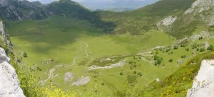
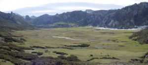
Enclave Name: Comeya Plain 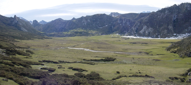
Categories of protection: The enclave is built into the SCI and SPA ES1200001 Picos de Europa (Asturias), within the National Park and Biosphere Reserve of the Picos de Europa.
Location: La Vega de Comeya is located in the Asturian municipality of Cangas de Onis.
Region: Asturias.
Coordinate Reference: 30TUN3894
Wetland area: 59 hectares
Altitude: 840 meters
La Vega de Comeya is a closed basin surrounded by steep slopes, which rests on a fairly waterproof substrate. It is a polje that adapts to the area’s tectonic structures, preparing its major axis parallel to the direction of the fault.
A small stream runs by the plain, which collects water from the surrounding hillsides and valleys and flows into a gulley in the Northwestern end of the valley.
The geographical position of Comeya establishes a climatology marked by a strong annual precipitation (2000 l) with an even distribution of rain throughout the year, except for a slight inflection in the summer, heavy snow in the winter and frequent fog in the summer, which determine low insolation and thermal insufficiency. Moreover, the intense karstification in the massif coordinates with the availability of water in some areas of the plain.
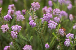
Biogeographically, this enclave is located in the transition between the territories of oceanic influence (Cantabrian-Atlantic subprovince) and more continentalized areas of the Cantabrian Mountains (subprovince Orocantabrica), although the presence of species and as Erica mackaiana and communities such as Erico mackaianae-Sphagnetum papillosi allows consideration as Cantabrian-Atlantic areas.
Most of the environment consists of rocky slopes of carboniferous limestone covered by gorse of Genista occidentalis and G. legionensis, while the Northern flank of the polje is a quartzite hillside carpeted with heather, among which cervunales develop and peaty areas which reach zones with increased surface runoff. The flat bottom of the basin is occupied by more or less flooded grasslands, small ponds and sphagnum bogs.
- MORE RELEVANT FEATURES
Singularity
The Comeya peatlands constitute the largest peat-bog system of the Picos de Europa National Park.Biologic and Ecologic Features
The most prominent element of the environment system is the bog system that developes in the central zone of the Comeya basin, constituted, together with other hygrophilous communities, by sphagnum bogs includible in the Erico mackaianae-Sphagnetum papillosi association. These peatlands, the most extensive in the LIC, and Picos de Europa National Park and Biosphere Reserve, represent the habitat 7130 Peatlands of coverage, of priority in this enclave for their conditions as active peatlands.Geomorphological Features
The Comeya basin is modeled mainly on limestone rocks of carboniferous age (Valdeteja and Picos de Europa formations), some superior coal- producing clastic materials (Soñín Formation) and, on the North bank, on a unit of quartzites the Ordovícida age (Barrios Formation). The origin of basin is associated with a network of fractures, including two direction errors WNW-ESE that constitute the Northern and Southern limits of the basin that elevate the Northern and Southern margins of the basin. Karst processes have been developed around this tectonic model and glaciers giving the current configuration of the form, which can be defined as polje, characterized by the presence of a small channel whose waters discharge into a sump or ponor.Historic and Paleo-ecological Features
The Comeya basin is filled with up to 57 m of sediments contained in a depression whose substrate is composed of limestone, clay and quartzite rock. The floors are of different nature responding to the complex history of the basin. Thus, much of the filler is made of red clay from the dissolution of limestone, occupying the central area of the tray. The moraine gravel carried by the torrent of Enol have generated stony soils (regosols) in the Southern area of the basin, while developed quartzite hillside colluvium on the Northern flank generated brown soils. Peat deposits, which reach 5m thick, are located in the central zone of the basin and generate a surface of histosols. The speed with which the mountain ecosystems respond, particularly lakes and peat depressions, to fluctuations in temperature and humidity make them an invaluable archive for studying the changes in climate. In particular, the lacustrine facies of the Comeya filler save data on episodes of erosion and runoff associated with deglaciation. Previous surveys show the existence of burned vegetation, dated at 40,000 years old, 35 feet deep and covered by lacustrine deposits. Moreover, the base of the peat at depth of 5 m has been dated to 8,350 years, when the basin ceased to be a lake.Habitats of Community Interest
Código Natura 2000 Denominación Prioritario 4020 Brezales húmedos atlánticos de zonas templadas de Erica ciliaris y Erica tetralix * 4030 Brezales secos europeos 4090 Brezales oromediterráneos endémicos con aulagas 6210 Prados secos seminaturales y facies de matorral sobre sustratos calcáreos (Festuco-Brometalia) *(Importantes sitios de orquídeas) 6230 Formaciones herbosas con Nardus, con numerosas especies, sobre sustratos silíceos de zonas montañosas * 7130 Turberas de cobertura *(Turberas activas) 7140 Ciénagas de transición y tremedales 8210 Laderas rocosas calcáreas con vegetación casmofítica Habitats According to Other Classifications: Phytosociological or Others
Código Natura 2000 Código INH Sintaxón 4020 302023 Gentiano pneumonanthes-Ericetum mackaianae 4030 303043 Daboecio cantabricae-Ulicetum gallii 4090 309053 Lithodoro diffusae-Genistetum legionensis 4090 309054 Lithodoro diffusae-Genistetum occidentalis 6210 521227 Brachypodio rupestris-Seselietum cantabrici 6230 523012 Nardo strictae-Caricetum binervis 7130 613012 Calluno vulgaris-Sphagnetum capillifolii 7130 613016 Erico mackaianae-Sphagnetum papillosi 7140 614010 Rhynchosporion albae 8210 72119D Saxifragetum paniculato-trifurcatae Flora
In the floristic aspect it is worthwhile to mention various types of sphagnum (Sphagnum mosses) that structure the peat bog and the presence of arnica (Arnica montana subsp. Atlantica), as all of them are recorded in the Habitats Directive as species that may be object of management.Fauna
Some of the taxocene of the Comeya meadow have been inventoried, as with leeches , of which two species can be found: Haemopis sanguisuga and Trocheta bykowskii. 10 species of dragonflies have also been found, including Aeshna juncea, listed as a vulnerable species statewide. The crayfish Austropotamobius italicus has been artificially introduced into the streams of the meadow but it seems to have disappeared from it few years ago. There are also artificially introduced trout and minnows. Most natural seems to be the amphibian taxocene in which five species are highlighted: the spotted salamander (Salamandra salamandra lavish / bernardezi), the alpine newt (Mesotriton alpestris), the palmate newt (Lissotriton helveticus), the common toad (Alytes obstetricans) and the common frog (Rana temporaria). Common lizards (Lacerta vivipara) are also found in this habitat and among the birds which most directly use the peat land, the common teal (Anas crecca) and snipe (Gallinago gallinago) stand out. Aside from the livestock, the mammal that can most affect the conservation of the peat land is the boar although it enters the wetland little.- PHOTOS